Fremont Lake Watershed Location
Click Image for Larger Map
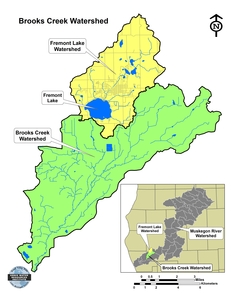
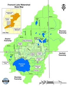
The Fremont Lake Watershed is 12,300 acres (19.2 square miles) in size and is located in the Brooks Creek Watershed, which is part of the Muskegon River Watershed. The watershed is in Newaygo County and encompasses portions of Sherman, Dayton, Sheridan, and Garfield Townships, and the City of Fremont. The watershed contains 977 acres (1.5 square miles) of lakes and ponds and 20.2 miles of streams and drains. The streams that flow into the lake include Lorden Lake Creek, Brooks Creek, Daisy Creek, Fremont Drain, Unnamed Drain, McDonald Drain, and Pell Drain. Fremont Lakes outlet is Brooks Creek, which is located on the south side of the lake.
Project Home Page
Fremont Lake Watershed Location
Fremont Lake Watershed History
Fremont Lake Watershed Land Use/Cover
Fremont Lake Watershed Monitoring
Fremont Lake Watershed Modeling
Conclusion & Recommendations
Contact Us