Geographic Information Systems (GIS)
What is GIS?
Global Positioning Systems
Watershed Interactive Mapping
What is a Geographic Information System?
A Geographic Information System is a collection of tools that are used to (1) create, display, modify and organize geo-spatial information and (2) permit the analysis of this geo-spatial data in "real world" decision making. Natural resource professionals manage a wide range of environmental conditions over a variety of landscapes and need to carefully monitor any changes or modifications to these systems over time. A GIS can be used by these managers to model and implement management alternatives and assess any potential impacts, so that they may sustain, protect and improve the resource.
With discrete geographic locations stored in a computer as sets of mathematical coordinates, any type of map can be produced. It is possible to create a map of the world, your neighborhood, or a map of the watershed you live in.
GIS also allows the user to display multiple layers simultaneously and analyze each layer in respect to the other. For instance, a map could display one layer showing soil type, an elevation layer, and a land use layer. By integrating these layers together, a user can decide where the best areas for agriculture would be.
Combining all of these aspects together, GIS can develop models allowing the user to predict processes using sample data. With the use of GIS layers, assumptions about the movements of forces like winds and tides, and other data like average rainfall for an area a user can predict spatially over time the spread of oil slicks, wildfires, or even erosion.
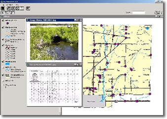
Newaygo County Road/Stream Crossing Decision Support System using ESRI Arcview 3.3 Software
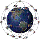
Global Positioning Systems (GPS)
The Global Positioning System was developed by the U.S. Department of Defense (DOD) as a global navigation system, originally made exclusively for the military, later released for civilian use. The GPS is constructed of more than twenty-four geosynchronous satellites orbiting the Earth, at an altitude of over twenty thousand kilometers. These satellites constantly transmit their positions as a a data signal to ground based stationary receiving stations around the world, fixing their orbiting locations as global geographic reference points. GPS mobile users can then determine their location as an accurate geographic position from anywhere on the earth, down to a few meters.
After collection of GPS coordinates, they can be used in a GIS. Let's say you wanted to map the locations of your favorite campgrounds throughout the state. After getting a GPS point for each campground you can use them in a GIS overlayed with other layers, such as roads, streams, and lakes.
For more information regarding GIS visit the GIS Lounge.
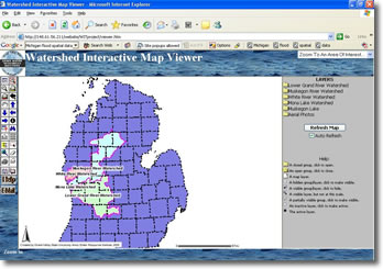
Watershed Interactive Mapping (WIM)
While GIS is relatively new much advancement has been made since the first software was available. One such advancement is the capability for distributing GIS and mapping services via the internet. Using ArcIMS (a component of ArcGIS) enables users to integrate local data sources with internet data sources for display, query, and analysis.
Anyone from the general public to our local decision makers can have access to a variety of data layers for many of our watersheds in Western Michigan using the WIM. The ISC developed the WIM as part of the Lower Grand River Watershed Project, but have extended it's use to many of the watersheds throughout Michigan.
The WIM can be a a very useful tool for local watershed groups, educational institutions, or even the general public who are interested in learning more about the watershed they live in. Click on the following link WIM to access the Interactive Mapping.