HIT Model Home Page
High Impact Targeting (HIT) Model
Introduction
FAQs
Tutorials
Demonstration Videos
Go to the HIT Model
Workshop Materials
Contact Information
Introduction
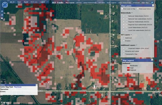
The High Impact Targeting (HIT) Model is an online tool designed to identify areas of extreme sedimentation and erosion within a watershed. The HIT Model uses Geographic Information Systems (GIS) and sometimes Bing Maps to display specific areas in farm fields that contribute the most amount of sediment deposition. This allows conservations districts, watershed groups, or other organizations to coordinate and develop an approach to reduce and control the erosion and sedimentation in their respective areas.
The HIT Model was developed by the United States Department of Agricultures Natural Resources Conservation Service (NRCS), the Michigan Department of Agriculture (MDA), the Huron Conservation District, and Michigan State Universitys Institute of Water Research (IWR).