Vessel Program Data Archive
AWRI's outreach program has been collecting and recording water quality data during educational cruises since 1986. We are making this long-term citizen science data archive publicly available for research and educational use.
The dataset can be accessed via two Google Sheets documents below by any interested parties, such as teachers who have participated in cruises or big data research efforts. Please note that the spreadsheets are "View Only," but you may make a copy of the file on your own device to manipulate as you see fit. Data are organized in separate spreadsheets by year as well as one very large sheet with all years.
Please contact Christina Catanese, Education Specialist, with questions about the vessel program's science data, to report any issues with accessing and using the data, or to share how you are using our data.
Immense thanks to the many students, instructors, and interns who have collected and recorded data, and done data entry over the years to make this dataset what it is!
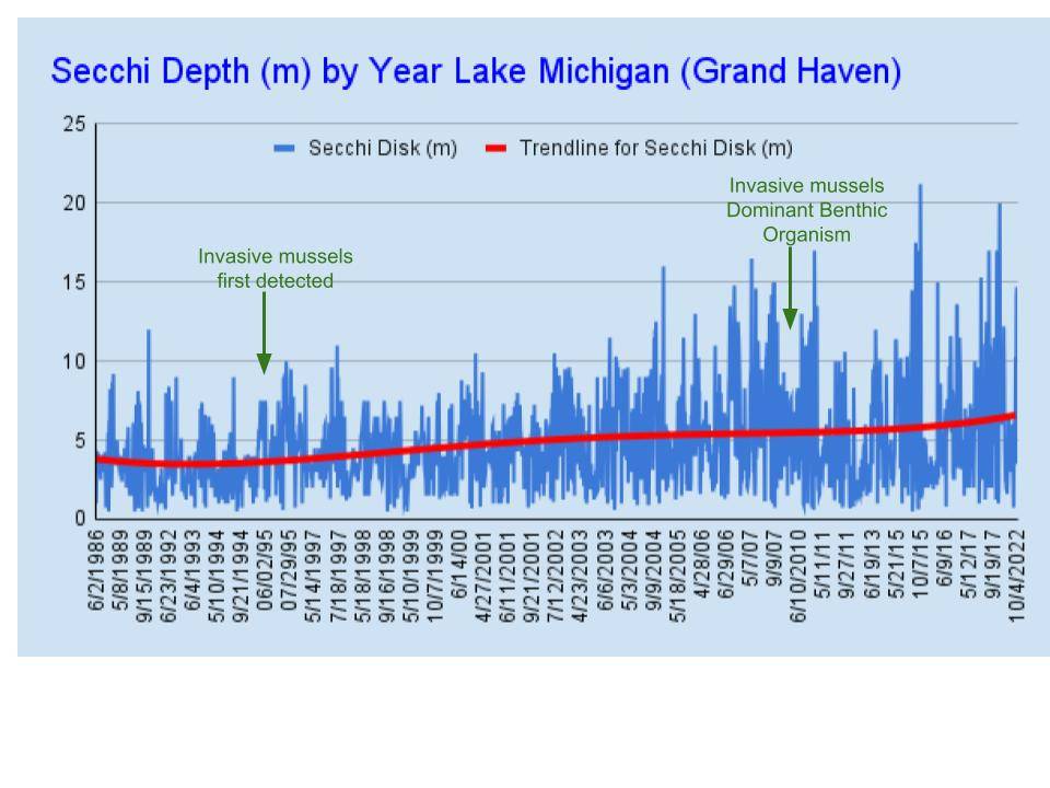
Water Clarity Through the Years
A long-term citizen science dataset allows many opportunities to explore changes observed over time. As one example, this graph was created by AWRI Science Instructor Bob Myers, showing increasing water clarity indicated by Secchi Depths collected on the D.J. Angus and annotated with the timeline of the introduction of invasive mussels into Lake Michigan.
Looking for more ideas on how to utilize these data?
Check out our lesson plan: Water Quality Monitoring: Lesson Plan for Exploring Time-Series Data