Fremont Lake Watershed Monitoring
Click Image for Larger Map
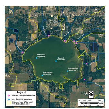
In addition to the lake, one sampling location was established on each tributary that flows into Fremont Lake (Lorden Lake Creek, Brooks Creek, Daisy Creek, Fremont Drain, McDonald Drain, Pell Drain, and an unnamed drain). The tributary sites were positioned at the furthest downstream point before entering the lake. This ensured that the samples taken at these sites were a good representation of the water quality and nutrient loads contained in each tributary (and by extension all the lands within that tributaries sub-basin) prior to its entry and mixing into the lake.
Monitoring results show that the highest pollutant loadings appear to originate from the Daisy Creek basin. This basin is 50% urban/built-up land and 19% agriculture. The flashy discharge, heavy erosion as indicated by high total suspended solid loadings, and elevated total phosphorus make this basin a focus area for urban stormwater and agricultural best management practices.
Brooks Creek and Fremont Drain also appear to be areas where phosphorus loading reductions need to occur. Fremont Drain appears to be influenced primarily by urban stormwater issues (71% urban/built-up land), while Brooks Creek is influenced by both urban and agricultural land uses (51% agriculture and 42% urban/built-up land).
For more monitoring results for Fremont Lake and its tributaries, read Chapter 4 of Baseline Study for Fremont Lake and its Connecting Waterways.
Project Home Page
Fremont Lake Watershed Location
Fremont Lake Watershed History
Fremont Lake Watershed Land Use/Cover
Fremont Lake Watershed Monitoring
Fremont Lake Watershed Modeling
Conclusion & Recommendations
Contact Us

