Muskegon River Watershed Project - Study Area

Project Home Page | Study Area | Water Quality | Project Information | Products | Related Projects | Partners | MRWA | Additional Resources
Size and Location
Subbasins
Land Use
Critical Areas
Interactive Mapping
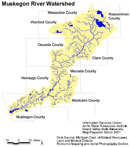
Size and Location A watershed can be defined as the area of land that captures rainfall and other precipitation and funnels it to a particular river, lake or stream. The Muskegon River Watershed drains approximately 2,723 square miles of land and is located in north-central Michigan. The river is approximately 219 miles long from its start at Houghton and Higgins Lakes down to its mouth at Muskegon Lake and, eventually, Lake Michigan. The Muskegon River Watershed is one of the largest watersheds in the State of Michigan and spans across the better part of nine counties: Wexford, Missaukee, Roscommon, Osceola, Clare, Mecosta, Montcalm, Newaygo, and Muskegon. Cities and towns located within the boundaries of the Muskegon River Watershed include; Cadillac, Lake City, McBain, Marion, Evart, Reed City, Big Rapids, Mecosta, Morley, Lakeview, Howard City, Newaygo, Fremont, and Muskegon.
Click here to view larger map
Click here to view larger map
Subbasins
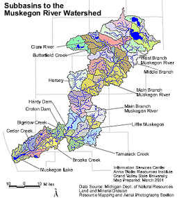
Approximately 94 tributaries flow directly into the main trunk of the Muskegon River. The primary tributaries include the West Branch of the Muskegon River, Butterfield Creek, Clam River, Middle Branch River, Hersey River, Little Muskegon River, Tamarack Creek, Bigelow Creek, Brooks Creek, and Cedar Creek. The Muskegon River Watershed has warm, cool, and cold water tributaries feeding into the mainstem.
Land Use
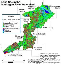
The greatest uses of land in the Muskegon River Watershed are for agriculture and forested lands. Agricultural land use is spread throughout the watershed with the bulk occurring in the middle and lower portions of the watershed. Patches of forest occur regularly throughout the Muskegon River Watershed and are most commonly found in the northeastern part of the watershed. Numerous wetland areas occur in the upper part of the Muskegon River Watershed and the headwater areas of many tributaries. Urban areas are mostly centered around Houghton and Higgins Lakes and the larger cities of Cadillac, Reed City, Big Rapids, Newaygo, Fremont and Muskegon.
Click here to view larger map
Click here to view larger map
Critical Areas
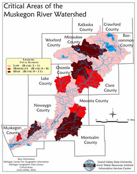
A critical areas analysis was completed for the Muskegon River Watershed in spring of 2001. The analysis, done on a sub-watershed scale, was based on the amount of developed land use (agricultural and urban), the amount of surface runoff that each stream receives, and the temperature fluctuation in cool-water streams. Each sub-watershed was given a rank score based on its degree of sensitivity to water quality impairments. The higher the numerical rank, the more critical the sub-watershed is. Not all subwatersheds were valued as critical for the same reasons. For example, some watersheds may have turned up critical because they contained a high percentage of developed land uses along with a high amount of cool water streams having high temperature fluctuations. In order to implement the best fitting management practices and public education activities in each subwatershed, it is important to look at the individual critical area category rankings to identify reasons why that particular subwatershed may be critical. These are some of the most critical subwatersheds which are the most sensitive and critical to protect: Brooks Creek, Tamarack Creek, Little Muskegon River, Middle Branch River, West Branch Clam River, Mosquito Creek (tributary to the Clam River), Butterfield Creek, and the West Branch of the Muskegon River.